
Geographic Information Systems (GIS) Technician
Is this for you?
- You enjoy maps, fieldwork, and turning messy data into clear visuals.
- You like tech tools, problem‑solving, and helping teams make faster decisions.
- You’re detail‑oriented and curious, with a service mindset.
Why this career is a great choice
If you love maps, drones, and data, this role lets you turn real world places into decisions. Demand is strong across government, transportation, and environmental work. You’ll split time between the field and computer, with steady pay, benefits, and clear growth potential into analyst, developer, or drone program lead roles. Your work supports storm response, grid upgrades, wildfire risk mapping, and conservation.
There is a clear upward trajectory: technician → analyst → senior → developer/data scientist or manager. Earn a drone pilot license and learn some basic coding, and you can quickly move into higher-level roles.
Source: Zip Recruiter

Explore Career Details

What the job really is
- Create and update digital maps that show things like land, buildings, roads, and energy equipment.
- Collect location information using drones, maps, or field notes.
- Build maps, dashboards, and web apps to support field crews and leadership.
- Analyze satellite and aerial imagery for change detection and planning.
- Maintain data quality, metadata, and standards; support emergency mapping.

A day in the life
- Check new map requests or updates from the team.
- Review location data and make updates on a computer.
- Collect information in the field or review data sent in by crews.
- Create maps or visuals to help explain information.
- Save work, share updates, and plan tasks for the next day.

What you will use
- Computer software for creating and editing digital maps.
- Tablets or mobile apps for collecting location information.
- GPS tools or drones that record where things are.
- Spreadsheets and simple databases to organize information.
- Communication tools to work with teammates and field crews.

What you need to bring
- Interest in maps, geography, or how places fit together.
- Willingness to work both indoors and occasionally outdoors.
- Comfort using computers and learning new software.
- Clear communication and documentation habits.

Where this career can take you
You can move up on this path:
- GIS Tech
- GIS Analyst
- Senior/Remote Sensing Analyst
- GIS Developer/Geospatial Data Scientist
- GIS Manager
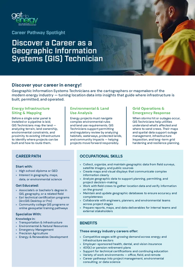
You can specialize your knowledge in:
- Transportation & Infrastructure
- Environmental & Natural Resources
- Emergency Management
- Precision Agriculture
- Energy & Renewables Development
You may also be interested in roles like:
- UAS Operations Lead
- Asset Manager
- Data Engineer
- Product/Platform Admin
This career is in these categories:
Ready to explore real openings for this career path?
Career Pathway Resource
Geographic Information Systems (GIS) Technician
(Click to download)